Alabama's Natural Bridge
.JPEG) |
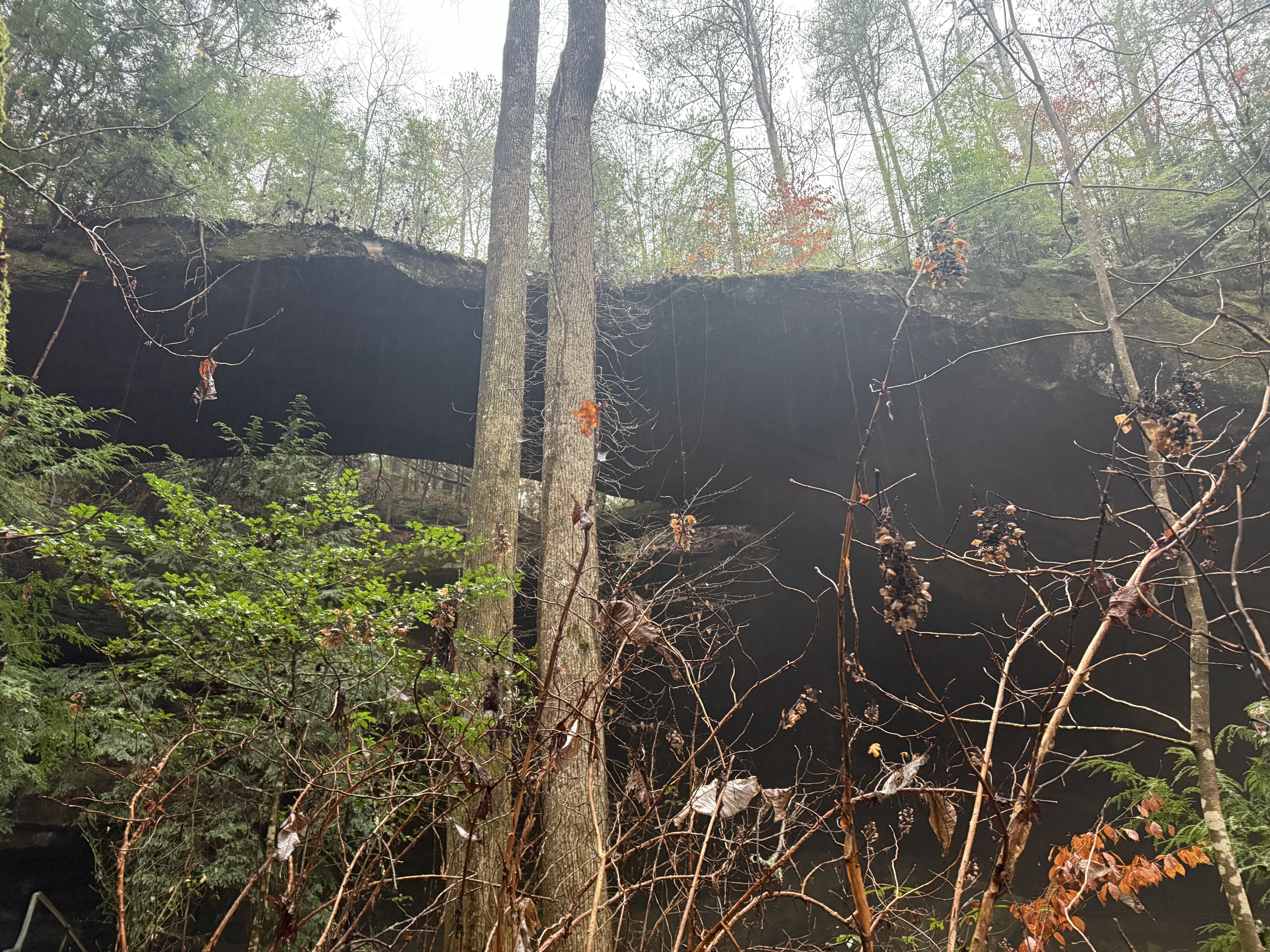
| Technically this is two natural bridges, or arches |
The longest natural bridge east of the Rockies is located in Natural Bridge, Alabama. They don't have an official website, but this site talks about the natural bridge:
Alabama Natural Bridge Admission is only $3.50 for adults. The park is open from 8 a.m. to 4 p.m. year-round. Natural Bridge Park is located at 315 Co Rd 3500 in Natural Bridge, Alabama. Its google maps location is here:
Natural Bridge Park You can reach it from Highway 278 in Alabama. It is 148 feet long and 60 feet above the ground. You aren't supposed to walk on top of the bridge, and I'm not sure how you would get up there anyway. The bridge is very thin and I fear it might fall if people walked on it.
We visited the natural bridge in December of 2024. It was a rainy day and the route was a little bit slippery, but there are hand rails along the route to keep you from slipping. There is a stream that runs through the park and bridges that lay over the stream. Near the beginning of the two-mile loop route through the park, there is an "Indian face" carved naturally in the rock. The natural bridge is near the beginning of the route. You can explore underneath the bridge in a sort of cave that is equipped with hand rails throughout, and man-made stairs in the rock. It is pretty amazing to be underneath the bridge.
As you continue on the route there are other caves to look at. There are arrows in the trees to keep you on the correct route. If it hadn't been rainy and cold, we might have explored more, but we opted to stay on the trail. There is a small waterfall at the far edge of the trail. The trail loops around and continues back over the bridges to the visitor center and parking lot. The visitor center has a shop inside with fun local things to buy.
Driving down highway 13 and then onto highway 278 there will be signs to the Natural Bridge, turn onto County Road 3500 next to the very large billboards for the natural bridge.
.JPG) |
| From Atlanta, follow I-22 until highway 13 |
 |
| There are large signs marking the entrance, when driving from either side of highway 13 |
 |
| The entrance to the park is so well marked, you cannot miss it |
 |
| In the parking lot, which has plenty of spaces, you can read more about the arch |
 |
| The parking lot was decorated for Christmas when we arrived, a couple days after Christmas 2024 |
 |
| The visitor's center has men's and women's bathrooms. There is a gift shop with lots of fun merchandise. My favorite thing to buy when I travel is earrings, and they had some great ones for a great price! The lady in the visitor's center was very kind. She warned us about how slippery the trail can be when it's raining and told us to be careful. |
.PNG) |
| As you can see, the natural bridge is literally right next to the visitor's center, only about a five minute walk onto the trail! The rest of the trail is very pretty views and interesting cracks in the rock, caverns, and a walk along the river. We walked it in the rain, and although it is slippery when wet, we used the hand rails to stay safe. The entire walk was under 2 miles. Very well worth it! |
 |
| starting out on a beautiful bridge with a beautiful view |
 |
| Both sides of the bridge had excellent views |
 |
| moss-covered rocks everywhere |
 |
| this fun little moss-covered couch-like rock |
 |
| the path is very well marked and very clear most of the time. A couple times I wasn't sure which way to go, but then we spotted an arrow attached to the trees telling us where the trail was |
 |
| Take a moment to have a look at the Indian Face. |
 |
| It looks like the side profile of a face |
 |
| Do you see the nose and the brow? |
 |
| And directly behind that, only a few seconds later on the trail, is the natural bridge! |
 |
| That was fast! It could have been a five minute trip, look at the arch, and leave! But of course we wanted to explore and stand under the arch and see everything there was to see there! |
 |
| The bridge is 148 feet long and 60 feet high. It is the longest arch in the eastern United States, and claims to be the longest arch east of the Rockies. The famous Delicate Arch in Utah is only 52 feet high, so this arch is higher. |
Once under the bridge, you can walk all along the inside of the cavern, holding onto a railing for safety, and see all the different views from underneath the arch.
 |
| My husband and I under the arch. It is hard to tell the scale of the arch -- it is much bigger than it appears in these photos |
 |
| Directly under the arch |
 |
| Another small arch |
 |
| That is an amazing tree growing out of the arch! |
 |
| Notice the tree growing on the very edge of the arch. Amazing! |
We did look for a way to get up above the arch, and if it hadn't been raining and slippery we might have kept trying, but we didn't want to risk it. I asked the lady in the visitor's center after our hike if there was a way to get up above the arch, and she said no. But there were lots of signs saying not to walk on the arch, so that makes me think that there actually is a way to get up there. We climbed a little ways up the slope of the mountain and I peeked around the corner and saw a rock that looked like it might have been placed for people to be able to climb up onto the ledge above, just to the left of the arch, but it would have been very slippery when wet. I do think that if anyone did try to walk on the larger arch or the small arch, it could easily fall -- both arches look very thin.
 |
| Check out that crack that goes clear from the ground to the top of the cliff. |
 |
| Throughout the hike there was hand rails for safety |
 |
| Many other caverns looked like they could become an arch someday |
 |
| The trail was very easy to follow most of the time, and whenever we wondered which way to go, we were quickly able to find it |
 |
| Sometimes arrows pointed the way to go |
 |
| The small waterfall at the far end of the loop trail |
 |
| I loved all of the bridges on the trail |
 |
| This very large fire pit would have made a great bonfire! |
 |
| The hike was so incredibly beautiful! |
Such a beautiful hike and so worth the drive to get there! If all you want to see is the natural bridge, you can easily view it only steps away from the parking lot. If you have a little more time and energy, the path that continues past the arch is very well worth it as well, and is only about 2 miles!
.JPEG)
.JPG)


.PNG)


.JPEG)
.JPG)
.JPG)


No comments:
Post a Comment